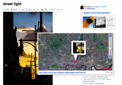
Now this functionality was previously already available to early adopter tech-savvy types who used Firefox with the GreaseMonkey plugin, which allowed an 'add geotags' link to be added to each Flickr photo page. This in turn got the location from Google Maps and that returned longitude and latitude data as tags on the image. These tags could then be used to collect images from a certain location or region, even outside of Flickr owing to its API.
This system worked, and still works, perfectly well in fact.
But... If all of that tech stuff goes over your head you're probbly thinking 'it sounds like a bit of a hassle'. And for some it is.
So Flickr have added their own system. And it works like this:
1. Drag your photo or batch of photos onto a map in the Organizr

2. View the map location from the photo page.

"Great", I immediately thought. But hang on a minute. There's one obvious shortfall: the map.
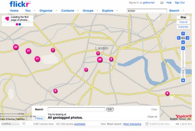
They're using Yahoo's mapping tool, of course. Flickr's photo elements work really nicely as usual, but the navigation on the map itself is clumsy and slow. And maybe it's all shiny and high-res for those of you in the USA, but the map data for London (you know that 'not so inconspicuous little town in the South East of England' ?) is terrible. Most of the roads aren't named, most smaller roads are missing and if I zoom into anywhere at the highest three zoom levels I just get grey. This is the closest I can get to London:

So, it fails completely because I have no idea where I'm pinning my photo!
In short, I'm afraid to say I think it's crap.
Also, it doesn't add geoTAGS to the photos. The location data is embedded. Now, arguably, tags weren't meant for positional data and some say they were undermining the tagging system, but so what? Wasn't it an inventive way to use them thought up by the users?
Well, apparently there's a way to convert them to the new system should you wish to. And Flickr's Stewart Butterfield laid to rest my fears that the existing geotagging system would cease to function in this thread.
Still, the bottom line is that I won't be using Flickr's map tool until it works properly. Maybe I'm spoilt by Google Maps but that means having a fast and easily navigable map with every road on it.
Until then, well, I know they're taking over the world but at times like these I wish it was Google that had bought Flickr and not Yahoo.

7 comments:
Well put. What a letdown.
Indeed, indeed.
I guess a little more time is needed before Yahoo manages to incorporate the lesser-known parts of the world outside the USA.
Indeed, indeed.
I guess a little more time is needed before Yahoo manages to incorporate the lesser-known parts of the world outside the USA.
Some related links. Many in the US have, understandably, taken to it more kindly than me.
The prolific Thomas Hawk:
www.thomashawk.com/2006/08/flickrs-new-geotagging...
TechCrunch:
www.techcrunch.com/2006/08/04/flickr-to-offer-drag...
It's crap because it doesn't work perfectly instantly?
If in three months' time the mapping detail for the rest of the world has seen no improvvements then I'm with you.
Did you try a hybrid view of London?
"It's crap because it doesn't work perfectly instantly?"
I was writing about my first impressions. I accept that it could (and hopefully will) improve over the coming months, but I was writing a review how it is at launch.
And, the Hybrid view doesn't work! Hybrid view is supposed to show Sattelite view combined with Map view, but it just shows Sattelite view at the moment. I guess that's because the map data is so innaccurate that it wouldn't line up properly.
Now yes, the sattelite photographic information itself is pretty good - hurrah! - but it's difficult to find most locations using Satellite view if they're not along obvious features such as the Thames.
Stewart Butterfield (Flickr co-founder) says in this post: "if we had launched a few months ago with Google maps underneath, you would have said exactly the same thing." This is not strictly true. Google Maps was still fantastic three months ago, and to the best of my knowledge has never had as poor data for the UK as Yahoo! does.
Though to be fair - as he alludes - it's probably a question of economics. Good map data is VERY expensive and once they have it it'll take a long time to set up and align with the Sattelite data. I'd imagine that's a very laborious task.
[Belated] update:
They have finally fixed it
Post a Comment